- Trip Facts
-
Duration:
4 Nights / 5 Days -
Grade/Difficulty:
Intermediate -
Rating:

-
- trip route
Deprecated: Function ereg_replace() is deprecated in /home/yetitrav/public_html/home/views/trip/collapsible.php on line 43
Kathmandu
Nuwakot
Dhading
Gorkha
Sundar Bazar
Pokhara
- Places to see in this trip
- trip group size
-
no. of people: 2
Deprecated: Function ereg_replace() is deprecated in /home/yetitrav/public_html/home/views/trip/collapsible.php on line 90
We can accommodate up to 16 people in a group for this trip.
-
- trip accomodation
-
Lodges
Tented Camps
-
- trip transportation
-
4x4 vehicle assistance is provided to transport luggage and gear from one overnight stop to another.
-
- trip meal
-
All meals are included during the trip, starting from lunch on the first day to breakfast on the morning after the end of the tour.
-
- trip's seasons
-
October
November
December
January
February
March
-
- trip cost includes
-
A professional bike guide
4x4 vehicle assistance to transport luggage and gears from one overnight stop to another
All meals during the trip, starting from lunch on the first day to breakfast on the morning after the end of the tour
Lodge / tented camp accommodation for four nights during the tour
One night deluxe hotel stay in Pokhara at the end of the trip
National Park permits
-
- trip cost doesn't include
-
Bikes and personal gears (Available for rent on prior request)
Return from Pokhara to Kathmandu
Alcoholic/non-alcoholic beverages
Travel Insurance
Emergency Evacuation
Tips and other personal expenses
Nepalese visa
-
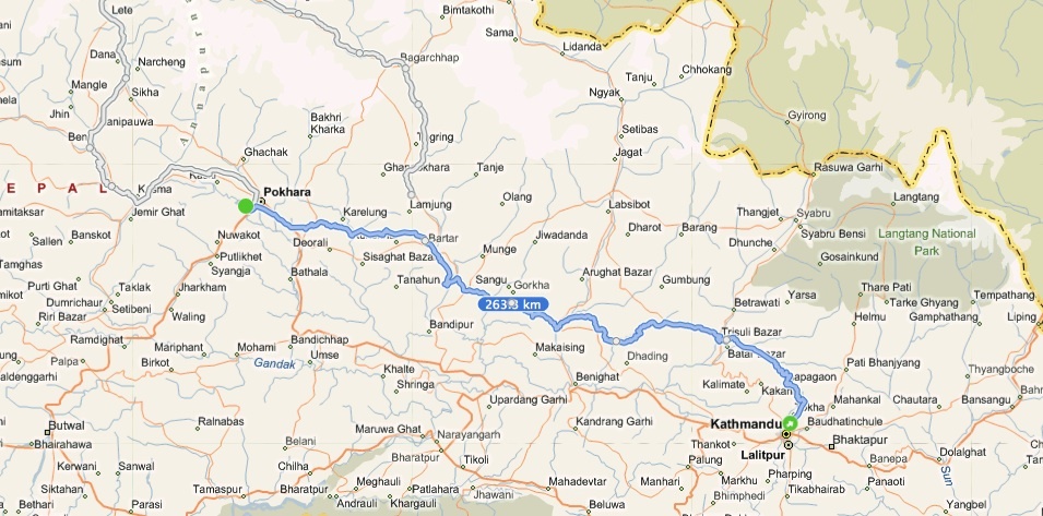
Trip Map
The Old King's Trail
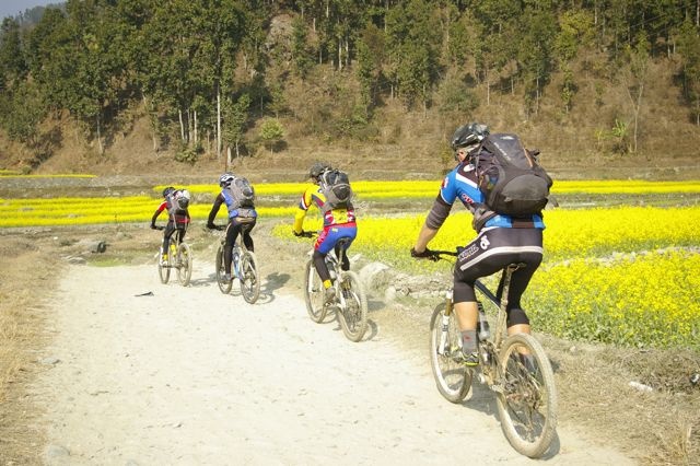
Originally said to be used by King Prithvi Narayan Shah and his cavalry in the 17th Century when he set off towards the Kathmandu Valley during the unification of Modern Nepal, not much has changed in this beautiful ancient route that connects two of Nepal’s biggest cities - Kathmandu and Pokhara. Riding through numerous mountain passes reffered to by locals as Bhanjyangs, free swinging suspension bridges over some of Nepal’s fiercest rivers, this route is the shorter yet much tougher variation of our 8-day long Spice Road trip. Passing through the old kingdoms of Nuwakot and Gorkha, which were the strategic headquarters during Nepal’s unification process, this trail takes you into the heart of Modern Nepal’s history. When we first set off to discover a route from Kathmandu to Pokhara completely on back country roads without ever setting wheels on the Prithvi Highway, many said it was impossible. But here it is, and we’d love to show it to you.
Terrain Type: Off Road / Dirt Tracks
Tour Type: Vehicle Assisted
Total Distance: 262 KM
Major Cities / Towns: Kathmandu, Nuwakot, Gorkha, Pokhara
The Old King's Trail
Duration: 4 Nights / 5 Days
Deprecated: Function ereg_replace() is deprecated in /home/yetitrav/public_html/home/views/trip/booking.php on line 5
Originally said to be used by King Prithvi Narayan Shah and his cavalry in the 17th Century when he set off towards the Kathmandu Valley during the unification of Modern Nepal, not much has changed in this beautiful ancient route that connects two of Nepal’s biggest cities - Kathmandu and Pokhara.
Terrain Type: Off Road / Dirt Tracks
Tour Type: Vehicle Assisted
Total Distance: 262 KM
Major Cities / Towns: Kathmandu, Nuwakot, Gorkha, Pokhara
book this trip
The Old King's Trail
Duration: 4 Nights / 5 Days
post your comment
comments / reviews for this trip
The Old King's Trail
Duration: 4 Nights / 5 Days
Deprecated: Function ereg_replace() is deprecated in /home/yetitrav/public_html/home/views/trip/itinerary.php on line 5
Originally said to be used by King Prithvi Narayan Shah and his cavalry in the 17th Century when he set off towards the Kathmandu Valley during the unification of Modern Nepal, not much has changed in this beautiful ancient route that connects two of Nepal’s biggest cities - Kathmandu and Pokhara.
Terrain Type: Off Road / Dirt Tracks
Tour Type: Vehicle Assisted
Total Distance: 262 KM
Major Cities / Towns: Kathmandu, Nuwakot, Gorkha, Pokhara
Day by day itinerary
DAY 1: KATHMANDU (1,265M) - SHIVAPURI NATIONAL PARK - BIDUR - NUWAKOT (890M)
Distance: 51.5 km. Elevation Gained: 1,168 m. Total Time: Approx 6 Hrs
After breakfast at the hotel, we load our rigs onto a 4x4 and drive 20 minutes out to Budhanilkantha on the outskirts of Kathmandu. The Kathmandu traffic can get very annoying and at times is unsafe to ride through, hence the reason we drive out to our start point. We get dropped off at Budhanilkantha, and our epic ride ki cks off with a 5 KM long climb straight away. This paved uphill road will give way to an off-road jeep track once we enter the Shivapuri National Park and then we head towards Gurje Bhanjyang (1,900m) - the pass from which we’ll exit the Kathmandu Valley. What follows from here is the longest downhill throughout the whole trip - an 18 KM long rocky descent that will drop us down to the Trishuli Valley at a mere 600m. After a short lunch stop at the foot of this downhill, we follow the Tadi River downstream for about 10KM before crossing our first suspension bridge of the trip. We then take on our second and final uphill of the day that’ll take us up to Nuwakot Durbar with a steep 6 KM long - 400 meters high climb. After a visit to the Nuwakot Palace in the late afternoon, we will spend the night at the Famous Farm, a warm and hospitable organic lodge housed in traditional Nepali cottages.
DAY 2: NUWAKOT (890M) - TRISHULI BAZAR - SAMARI BHANJYANG - DHADING BESI (608M)
Distance: 48.8 km. Elevation Gained: 1,450 m. Total Time: Approx 7 Hrs
Today’s ride begins with a 6 KM ride down the Nuwakot hill and into Trishuli Bazar. We cross the mighty Trishuli River and head up a slight grade through the upper Trishuli Valley. The beautiful sight of this serene valley is the calm before the storm as what lies ahead at the end of this windy path is the steepest climb of this entire trip - the ascent up to Samari Bhanjyang. Its not just the grade that will be difficult to tackle, but the extremely rocky terrain means the only way out is to spin it on the smaller gears as you and the bike will bounce all over the place if you try to attack it and pick up some speed. On top of this pass is a small settlement where we will take our lunch break for the day; but the day’s hard work is far from over. The next 5 KM down the west face of Samari is an exciting free flowing downhill, followed by a gentle stretch till we come across a suspension bridge. Up next on the day’s menu is a segment containing a series of eight short (half kilometer) climbs and descents.This section can get tricky as its very easy to get carried away and spend all your reserve energy thinking that the day’s big climb is already behind us. The series of short climbs and falls finally come to an end at Sorhaghare where a slightly longer variation await us - a four kilometer down followed by a four kilometer climb, which is then followed by a super fast 5 kilometer dirt road downhill through small villages leading up to our stop for the night at Dhading Besi.
DAY 3: DHADING BESI (608M) - MURALI BHANJYANG - BUNGKOT GHAT - GORKHA (1,052M)
Distance: 52.4 km. Elevation Gained: 1,609 m. Total Time: Approx 8 Hrs
Today we ride to historic Gorkha. This is considered by many to be the toughest day of this trip. This capital of the once-mighty kingdom is a hilltop fortress, so there is a big climb to be done on the second half of the day. The last time we started this day, a team of 8 riders ended up gobbling eighty toasts over breakfast; we suggest you do the same, and save some of your granola bars and energy drinks to get you to the end. We start off the day in typical fashion with a gentle and smooth 17 KM long climb upto Murali Bhanjyang (1,120m). This is one of those pleasant climbs that doesn’t really feel like hard work, and for many its exactly the sort of start they look for to warm their bodies up on a chilli morning. We get off the smooth path at Murali Bhanjyang and take off on a 13 KM wild descent through the dense forest of Sakhu, going down all the way to an elevation of 400 meters to the banks of the fierce Budhi Gandaki river. We cross the Budhi Gandaki on a tricky suspension bridge and stop at the 4-house-village of Bungkot Ghat for lunch. The next three kilometers after the lunch break is a pleasant ride, giving us enough time to get warmed up again before we come face to face with our nemesis of the day - Gorkha hill. To conquer Gorkha, we have to conquer this 8 KM climb that starts off very steep and eases off towards the end, covering a vertical distance of over 600 meters. The next 12 KM all the way to our destination is mainly all Himalayan Flats - a term commonly used by trekkers who come to Nepal (‘Himalayan Flats’ usually contain several short ascents and descents, but generally hover around in similar altitude). The spectacular view of the Gorkha Durbar with Mt. Manasalu (8,163m) as the back drop is probably the best painkiller in the world after a long hard day in the saddle. We spend the night at the comfortable Gorkha Inn.
DAY 4: GORKHA (1,052M) - PALUNGTAR - TURTURE - SUNDAR BAZAR (620M)
Distance: 46.1 km. Elevation Gained: 871 m. Total Time: Approx 5 Hrs
Compared to the previous days’ rides, today’s ride is a walk in the park. Today we simply take it easy, let our bodies recover, admire the view of the majestic Manasalu range, and finally get a chance to notice how much the terrain, culture, and ethnicity has changed since we departed Kathmandu only 3 days ago. We have now officially hit the lower hilly region of Nepal, and what better way to start off the day than an awesome 10 KM long downhill that takes us more than 600m below Gorkha; returning back is surely not an option. At the end of the downhill, at Chepetar, we join a paved road that takes us down to the Madi river crossing. Here we get off the paved road to take a suspension bridge across the river. At the far end of the bridge, we do a little role reversal and carry our bikes, and walk about 10 minutes up a flight of stairs. A gentle 5 KM climb will follow after which we roll with the down grade for the next 10 KM where we cross the Marshyangdi River and stop for lunch at Turture. After lunch we continue on the paved road for the next 14 KM before we turn right and climb up a 2 KM uphill to reach Sundar Bazar. We camp next to a stream on the outskirts of this bustling town.
DAY 5: SUNDAR BAZAR (620M) - MAJKOT - BEGNAS - POKHARA (800M)
Distance: 63.7 km. Elevation Gained: 1,486 m. Total Time: Approx 8 Hrs
The last day of our Kathmandu - Pokhara epic. Distance wise this is the longest day of the trip. However, once you descend down into the Pokhara valley, the last 24 KM will just pass you by with the excitement of finishing this strenous 5 day ride. We leave Sundar Bazar and follow a 14 KM climb towards Dhimire Bhanjyang. The climb gets off to a steady start but gets really steep for the final 6 KM. But according to the laws of Physics, what goes up must come down, and hence we set off on what is arguably the best downhill of this trip - an 11 KM fast rocky downhill that requires a lot of concentration and skilled technical abilities. We stop for lunch at the 25 KM mark and head off on a 9 KM pleasant steady climb to Majkot Bhanjyang. This is the last hill before you reach your destination - Pokhara Valley. Once we get to the top and regroup, we set off on a 5 KM descent - the last off road downhill section of our trip. Riding on for a few minutes after the base of the hill, we will get a much awaited view of Rupa Lake followed shortly by a breathaking view of Begnas Lake. There is work to be done still as Pokhara city is a further 20 KM away. We ride on an upward grade for the next 5 KM before we join the paved road that runs straight into downtown Pokhara, parallel to the Prithvi Highway - the main highway that connects Kathmandu to Pokhara. The final 15 KM will just pass us by as we dust ourselves off, empty the bottles, finish up our granola bars, and get into formation to do a victory lap at Lake Side.

Be the first to comment on this trip.